I spent some time in my local metal detecting shop recently and had the opportunity to listen as a customer purchased a brand new Minelab Equinox 600. He was so excited! It was just the three of us in the shop, so it was a friendly discussion of experience.
He asked questions about beach hunting like, “Do I need a pinpointer?” “What kind of scoop should I buy?” “Is low tide the best time to search?” Everyone has a different answer for those questions, and my advice is always that experience is going to be the best guide!
I shared some stories of beachgoers asking me if I could find their lost item. I will absolutely help someone find their item if they can describe it very well, but there are a lot of factors to consider when you set out to find something specific.
That’s when we started talking about how things move in the sand – including the longshore drift. Though we didn’t refer to it as “longshore drift” while talking in the store, that’s the name of the process we were referring to when discussing how lost items move along the coast over time. For this topic I consulted my smart sister Kim – she’s a geologist who helped me understand this process on a deeper level!
What is longshore drift?
The basic definition of longshore (littoral) drift is the movement of sand and sediment along a shoreline over time, with the longshore current. The longshore current refers to the movement of water along a shoreline which is caused by the energy generated by breaking waves.
Let’s start by watching this short video:
The longshore drift is determined by the prevailing wind – that is the direction the wind generally comes from in that area. Most of the time, waves approach coastlines at an angle and push sand and sediment along the beach at that angle. The backwash pulls the sand straight back, where it becomes subject to the waves again.
Because of this, the sand will travel along the coast in the direction of the longshore current. That’s longshore drift in a nutshell!
How do longshore drift and longshore current relate to metal detecting?

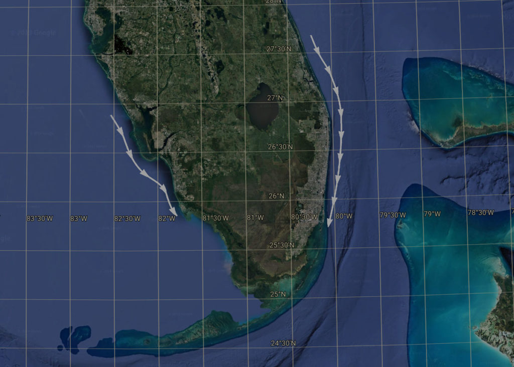
The white arrows show the general drift south along these shorelines in Florida. (Not to be confused with the Gulf Stream!
Understanding longshore drift and current will help you learn how a beach changes over time, inform your choice of areas to hunt, and may help when you are searching for a lost item.
Put it to practice: Detect Smarter
Understanding how a beach and its sand and sediment change and move over time can help you find hot spots – areas where you notice patterns for the types of objects you find.
Related to the longshore drift, you can detect smarter by paying attention to where beachgoers spend their time on the beach and in the water, and remembering that over time, the things they lost may end up farther along the coast.
Put it to practice: Find a Lost Object
I’ll start by saying that this is as much art as science, and it’s a lot of science. It’s understanding basic geology and physics, then combining that with practical knowledge of human behavior! In addition to knowing how the weight, size, and shape of an object combined with the coarseness of the sand will impact how deep an object can go, the longshore drift can determine the position along the coastline.
1) Know your beach. You can use data from agencies like NOAA (see this handy PDF) to determine the prevailing wind direction for your area. Personal experience and observation if done in a methodical way can help too.
2) Understand your target. The basic questions you should know the answer to include: Where was the item lost initially? How long ago was it lost? What are the weight, shape, and metal type of the object? What weather or other factors have occurred in this location during the time since it was lost?
3) Remember you’re dealing with humans! People have inaccurate memories when it comes to their position in the water or on the beach. They may give you a spot on a building they remember seeing, or a general area between two lifeguard towers.
They also may not know their lost object as well as they think. When someone says “gold ring” or “silver bracelet,” they may be incorrect. Is the object simply silver in color? Is it actually stainless steel, pewter, silver plated?
Example
 If someone lost a lightweight silver ring with a stone setting in the water at the shoreline two months ago, where should you begin your search for it?
Most people use a grid method to methodically search an area – that’s great once you know where the likely area should be! First, you need to know in what direction the item may have moved over time. Did any strong storms impact the area in the time between losing the item and now? What has been the prevailing wind direction in the past two months?
The better you know the area, the easier it will be for you to know the factors impacting that beach. In this example, you might start by creating a grid in the general area where the person said they lost the ring, and track first in the direction of the longshore current that has been in place for the time since the item was lost.
The prevailing wind direction can vary by season, or by the environment you’re in. Using Miami as an example, the prevailing wind direction in the summer months is from the East/Southeast. However, the longshore drift is generally south over a long period of time!
So most Florida detectorists might say, “lost items on Florida beaches move south.” That can be generally true, given enough time for the object to become subject to longshore drift, but for objects lost more recently, the direction may be north!
I hope this has helped you to understand longshore drift and current. Does your local beach have a clear direction? Many beaches have problems with erosion for this reason and go through renourishment projects.
What is your beach like? Leave me a comment below!
Resources
Beaches
Learn more about Waves, Beaches, and Coastal Erosion reprinted from “Natural Hazards and Disasters” by Donald Hyndman and David Hyndman.
Wind
A great tool for wind data and forecasts from Windfinder.
Renourishment Projects
As an example, read Miami-Dade County’s Beach Erosion Control Master Plan

